
Credible. Evidenced. Valued.
Ecometric measures soil organic carbon on farms once a year. Real soil samples are analysed by dry combustion in an ISO-accredited laboratory and tied to satellite imagery at 100 readings a hectare, and the error is measured and deducted in full. The measurement comes first. Emissions reporting and carbon credits are optional tiers built on the same data. SOC change is the early warning system for the condition of your production machine.
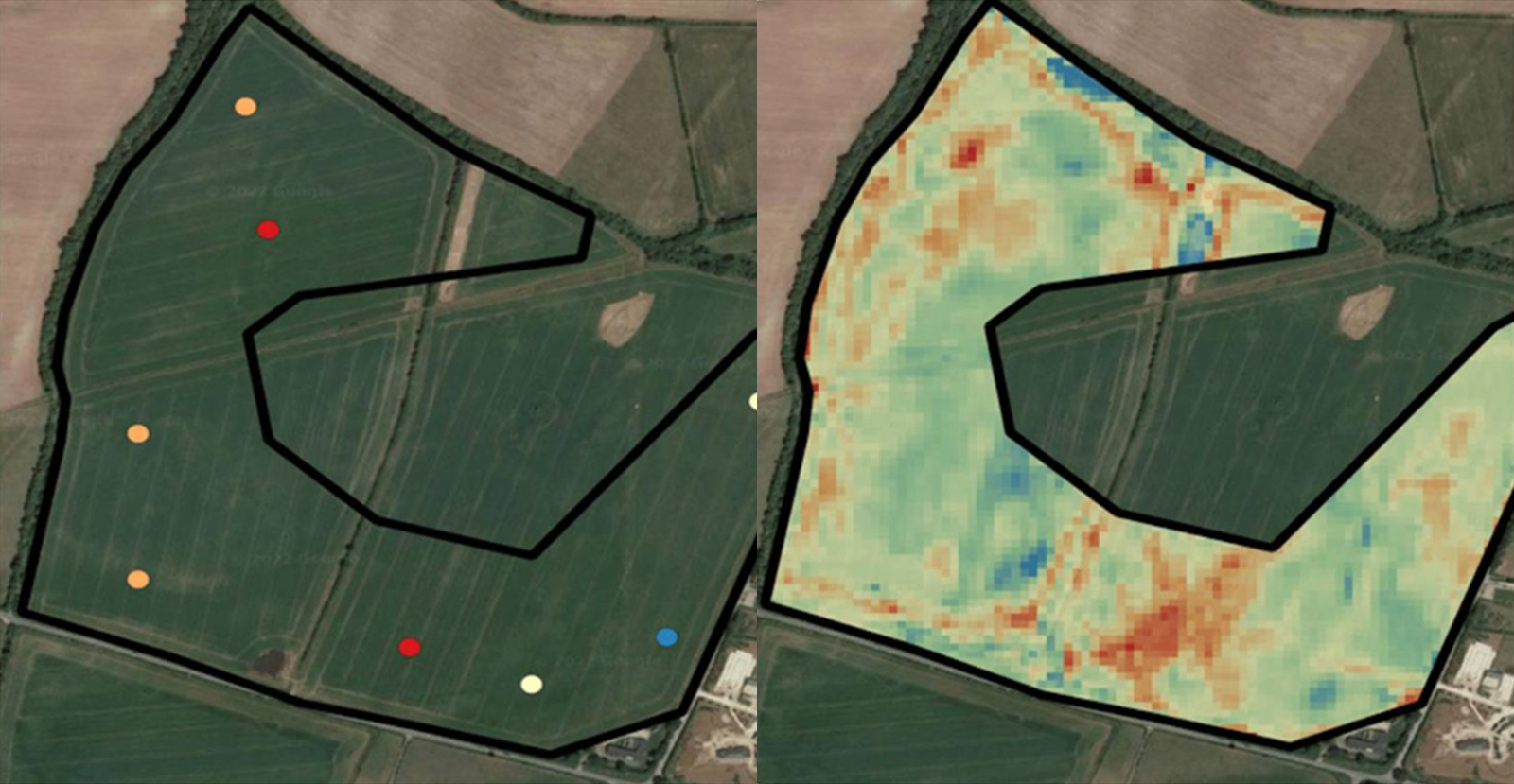
Measured, not modelled.
Activity-based models estimate soil carbon from a list of the practices a farm says it follows. We measure instead. Real samples anchor every result, and satellite and AI extend them across the field.
The image above shows the difference between a pure soil sample report, where there is only data at the point of sampling, and the Ecometric report, where our AI relates soil sample and spectral information to provide a data point every 10 metres. How soil carbon is measured, step by step.
How the measurement works
Every round is measured the same way whichever tier you are on.
Step One
SAMPLE
Real soil samples on every farm we monitor, taken in the same window each year, field by field.
Step Two
ANALYSE
Each sample is analysed by dry combustion in an ISO-accredited laboratory.
Step Three
MAP
Our AI ties the samples to satellite imagery at 100 readings a hectare, a value every 10 metres.
Step Four
TEST THE ERROR
The error is measured against samples the AI never saw, then deducted in full.
Step Five
REPORT
Change against your own baseline, with the accuracy stated.
Step Six
STAY AUDIT-READY
Every round is measured to full Registry standard whichever tier you are on, so the numbers hold up to all audit standards.
Soil carbon and next year’s yield.
We measure the same fields year after year to track the effect of each rotation on the soil. Across our monitoring programmes we are seeing an emerging relationship between soil organic carbon stock change and yield stability.
Stable and increasing carbon stocks protect the following year’s yield against too much water or too little. Without monitoring soil health, yield risk goes unseen until the next weather event strikes. This risks business continuity at farm level and food security at national scale.
Four early signs
Worth watching. None is proven yet.
01 · A yield edge
Farms gaining soil carbon tended to out-yield neighbours on the same crop.
Evidence 3 out of 5
02 · A season later
Soil carbon gains tended to show in the next year’s yield.
Evidence 2 out of 5
03 · Wider rotations
More crops in the rotation tended to mean more carbon gained.
Evidence 2 out of 5
04 · Legumes hold yield
Beans or peas in the rotation held yields up better.
Evidence 3 out of 5
Evidence out of five: three is promising, five would be proven. Proving these needs more farms, more years and fuller records.
Measuring does not stop a drought. It tells you whether your soil is getting better or worse at handling one. What five years of monitoring show.
Independent scrutiny
Reviewed four times before accreditation
Our method went through four rounds of independent scientific review to earn Regen Registry accreditation and its own credit class. See the Ecometric credit class.
A published methodology
The full methodology for soil organic carbon estimation in regenerative cropping and managed grassland is published on the Regen Registry for anyone to read. Read the methodology.
Audited, verified and rated
The method is audited by Carbon Direct and Nova-Cert, verified to ISO 14065 and rated by BeZero in the global top 30%. It is the same evidence standard our credit buyers audit us against.
Written for WWF
WWF commissioned our team to write the soil health measurement paper for Codex Planetarius, its proposed global standard for the environmental performance of traded food. Published December 2025. Read the paper.
Error deducted in full
With physical sampling to calibrate and train our AI system, quantification accuracy remains tethered to ground truth. Error is carefully evaluated through the methodology and deducted in full to ensure the most conservative result. How the error is measured and deducted.
Measure your soil this season.
Ready to measure your soil, field by field? Send us your SBI number and hectares and we will send a written quote within two working days.
